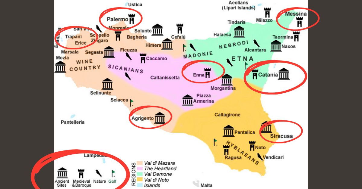
Detailed & Tourist Map of Sicily, Italy
Exploring Sicily is an experience of history, sunshine, culture, and breathtaking views. This large island, floating off the southern tip of Italy, offers everything—from ancient Greek ruins and baroque towns to golden beaches and volcanic adventures. A detailed map of Sicily, Italy, is your best companion to navigate through its charming regions, coastal drives, and hidden gems. Whether you are a first-time visitor, a travel planner, or an explorer, this guide helps you understand the geography, attractions, transportation, and tourist routes of Sicily.
Introduction to Sicily: The Island of Diversity
Sicily, the largest Mediterranean island, sits between Europe and Africa. It’s a land shaped by thousands of years of cultural exchanges — from ancient Greeks and Romans to Arabs and Normans. The capital city, Palermo, is known for architectural contrasts and bustling markets, while Mount Etna brings you face-to-face with one of the world’s most active volcanoes.
A tourist map of Sicily is not just a navigation tool; it’s a storybook revealing how nature and culture coexist harmoniously. On the map, you’ll spot everything from archaeological sites in Agrigento to coastal escapes near Cefalù and historic wonders in Syracuse.
Geographic Overview of Sicily
| Region | Major City | Highlights | Best Time to Visit |
|---|---|---|---|
| Palermo Region | Palermo | Norman Palace, Ballarò Market | March – June |
| Catania Region | Catania | Mount Etna, Baroque architecture | April – October |
| Messina Region | Messina | Ferry gateway from mainland Italy | All year |
| Agrigento Region | Agrigento | Valley of the Temples | April – May |
| Trapani Region | Trapani | Salt flats, Egadi Islands | May – September |
| Syracuse Region | Syracuse | Greek Theatre, Ortigia Island | March – June |
| Enna Region | Enna | Castle of Lombardy, panoramic views | March – May |
Sicily’s landscape is characterized by coastline cliffs, inland hills, fertile plains, and volcanic terrains. The distance from Palermo (north coast) to Syracuse (southeast coast) is roughly 260 kilometers, making the island perfectly suitable for a 7-10 day scenic road trip.
Sicily on the Map: Location and Accessibility
Sicily is separated from mainland Italy by the narrow Strait of Messina. On most tourist maps, you can find Sicily positioned at the crossroads between the Tyrrhenian Sea to the north, the Ionian Sea to the east, and the Mediterranean Sea to the south.
How to Reach Sicily:
- By Air: Main airports – Palermo (PMO), Catania (CTA), Trapani (TPS), and Comiso (CIY).
- By Sea: Regular ferries from Naples, Reggio Calabria, Genoa, and Malta.
- By Car or Train: From mainland Italy via ferry across the Strait of Messina.
Must-Visit Places Highlighted on the Tourist Map of Sicily
Every tourist map of Sicily Italy marks the island’s top attractions, UNESCO heritage sites, and coastline drives. Below are the unmissable places divided by interest type.
Historic Landmarks
- Valley of the Temples (Agrigento): Ancient Greek ruins beautifully preserved.
- Palermo Cathedral: A perfect fusion of Arab-Norman architecture.
- Syracuse and Ortigia: Ancient Greek theatre, baroque alleys, and sea-facing piazzas.
- Taormina: The Greek Theatre with panoramic views of Mount Etna.
Natural Wonders
- Mount Etna: Europe’s tallest active volcano, accessible by guided tours.
- Aeolian Islands: A volcanic archipelago ideal for boat trips.
- Scala dei Turchi (Stair of the Turks): Iconic white limestone cliffs near Agrigento.
- Alcantara Gorges: Volcanic canyons carved by the Alcantara River.
Coastal & Beach Destinations
| Destination | Location | Attraction Type | Travel Tips |
|---|---|---|---|
| Cefalù | North coast | Sandy beaches, seaside cathedral | Ideal for summer stays |
| San Vito Lo Capo | Western tip | Golden beaches, turquoise water | Great for snorkeling |
| Fontane Bianche | Near Syracuse | Family-friendly beach | Accessible by bus or car |
| Scala dei Turchi | Agrigento | Cliff views + swimming | Visit early morning |
Sicily’s Regional Map: North to South Highlights
Northern Sicily
This coastal line borders the Tyrrhenian Sea, filled with beach towns and mountain villages. Palermo dominates as the cultural capital, with nearby Monreale, Cefalù, and Madonie Mountains offering scenic exploration.
Eastern Sicily
The southeastern curve from Catania to Noto represents the Baroque heritage trail. The Mount Etna map zone is a highlight for trekking and photography. Taormina, Giardini Naxos, and Acireale are also tourist favorites.
Western Sicily
Trapani and Marsala stand out for salt pans and archaeological sites. The Egadi Islands on the west are accessible via ferry and often marked on tourist maps with diving symbols.
Southern Sicily
Agrigento’s “Valley of the Temples” anchors the region, while Ragusa and Modica are famous for their chocolate and architecture.
Digital Maps, GPS, and Tourist Apps
Modern travelers rely on digital maps of Sicily Italy available through platforms like Google Maps, Apple Maps, or specialized travel apps such as Visit Sicily or Italy Offline Map.
Key Advantages:
- Real-time route tracking and gas station locators.
- Offline mode for remote or rural areas.
- Highlighted scenic routes like the SP92 (Etna Road) or SS115 coastal route.
- Local trip suggestions and restaurant finders.
When planning a multi-city trip, use custom map layers to mark destinations such as:
- Palermo → Cefalù → Taormina → Catania → Syracuse → Agrigento → Trapani
Sicily’s Local Transport Map
| Transport Type | Main Routes | Travel Time (Approx.) | Recommended For |
|---|---|---|---|
| Train | Palermo – Catania, Palermo – Messina | 3–4 hrs | Coastal sightseeing |
| Bus | Intercity & village routes | Affordable | Exploring inland towns |
| Car Rental | Island-wide | Flexible | Ideal for road trips |
| Ferry/Boat | Milazzo – Aeolian Islands | 1–2 hrs | Island hopping |
Driving around Sicily is popular because roads connect most tourist attractions efficiently. The A19, A20, and A29 highways are key routes linking Palermo, Catania, and Trapani. Always check your digital tourist map for toll roads and parking areas near major attractions.
Understanding the Tourist Map Symbols
A tourist map of Sicily typically uses color codes and icons to represent travel zones and attractions.
| Symbol | Represents | Area Example |
|---|---|---|
| 🏰 | Historical sites | Syracuse, Agrigento |
| ⛰️ | Mountain or volcano | Mount Etna |
| 🌊 | Beach or coast | Cefalù, San Vito Lo Capo |
| 🏡 | Traditional town | Ragusa, Noto |
| 🚗 | Road trip stop | Palermo–Taormina route |
These icons help travelers visualize the type of experiences within each region at a glance—making map reading simple even for first-timers.
Top Tourist Circuits and Routes in Sicily
1. The Classical Heritage Route
Palermo – Agrigento – Syracuse – Taormina
Explore temples, theatres, and ancient ruins in sequence.
2. The Natural Sicily Road Trip
Catania – Mount Etna – Alcantara Gorges – Cefalù
Perfect for hikers, photographers, and nature enthusiasts.
3. The Hidden Towns Circuit
Modica – Ragusa – Scicli – Piazza Armerina
A route through southeastern Sicily’s baroque artistry.
4. Island-Hopping Route
Trapani – Favignana – Lipari – Stromboli
Explore unique volcanic islands with ferry transfers.
Local Culture & Cuisine Along Your Route
When following your tourist map of Sicily Italy, you’ll experience strong local flavors. Each region brings distinct culinary highlights:
- Palermo: Arancini, cannoli, and seafood couscous.
- Catania: Pasta alla Norma inspired by Mount Etna.
- Ragusa: Famous for Modica chocolate.
- Marsala: Sweet fortified wine.
Local food spots are often marked on interactive maps, offering ratings and suggestions via AEO-driven results like “best trattoria near me Sicily” or “family restaurants in Taormina.”
Safety, Connectivity, and Weather Tips
- Best Travel Time: April to June and September to October.
- Road Conditions: Well-maintained highways but narrow village roads—use map zoom.
- Internet Access: 4G and 5G widely available; for remote areas, download offline maps.
- Languages: Italian, with some English near tourist hubs.
Quick FAQs
What part of Italy is Sicily in?
Sicily is in southern Italy, separated by the Strait of Messina, and is the largest Mediterranean island.
How long does it take to tour Sicily?
A complete road trip takes about 7 to 10 days, covering major landmarks.
Which is the best city to start?
Palermo is ideal for cultural exploration, while Catania is best for visiting Mount Etna.
Is Mount Etna visible on the tourist map?
Yes. It appears prominently in the eastern region near Catania, often marked with a volcano or hiking symbol.
What are the top tourist maps available online?
Google Maps, Visit Sicily Interactive Map, and regional tourism portal maps from Sicilia Turismo.
Why Use a Tourist Map Before Visiting Sicily?
Using a detailed and tourist map of Sicily Italy ensures that you:
- Save travel time between regions.
- Identify hidden villages and lesser-known beaches.
- Plan weather-dependent routes (e.g., morning visits to Etna).
- Customize itineraries based on personal interests like history, food, or nature.
Maps—both physical and digital—transform your trip from spontaneous wandering into a structured yet flexible adventure.
Conclusion: Discover Sicily Like a Local
A detailed map of Sicily isn’t just directions—it’s your introduction to a living museum of civilizations surrounded by Mediterranean beauty. From Palermo’s architectural mosaics to Catania’s volcanic landscapes, Sicily captures Italy’s essence at its most authentic.
Plan, explore, and let every marked point on the map become a story to tell. With your tourist map of Sicily, Italy, every journey leads to discovery.
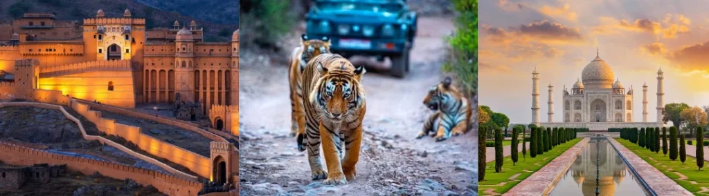
You may also like : Same Day Taj Mahal Tour By Car From Delhi, Taj Mahal Tour by Gatimaan Express Train, Jaipur One Day Tour Package by Car
Follow Us On : Quora, Reddit